Wednesday 5 January 2011

A Simple Method of Plotting GPS Position

When we first started short coastal cruising we used traditional chart work and position fixing methods, dead reckoning, compass bearings and cocked hats were practised.
At night school, on an Ocean Yachtmaster course, I learnt the art and science of Astro navigation and bought a plastic Ebco sextant to hone my skills. We used to holiday in the 80’s at the Ferry Boat Inn and early in the morning I would take the Mirror dinghy to the mouth of the Helford river where I could see the Sun and horizon. On my return I would inform family and friends that I had been able to determine my position line correct to 2-5 miles. This was normally greeted with hoots of derision and comments such as “we haven’t had to move from here, but know exactly where we are to a few yards, just ask us next time you want to know”. I still keep Annual Ephemeral tables and occasionally practice position fixing on paper, although pocket calculators and computer have simplified the calculations. A few years ago I replaced the plastic sextant with a very well made 2nd hand Russian model, bought for a few pounds in Singapore.
In the early 90’s I bought my first GPS. It was expensive, ( about $1000), heavy, ate batteries and would give lat/long accurate to about 50-100metres. It would store 20 waypoints and show bearing / distance to WP from current position. It was a marvellous tool.
Pre car satnav I bought some software to run on my laptop and linked this to the GPS. I used this to help me drive all round the UK and Europe in spite of the inaccuracies in the position and the maps. The software must have known I was using a nautical GPS because driving up the A38 it would normally show me in the Trent and Mersey Canal.

How things have changed. A few months ago I bought a fancy smart phone. As well as being able to browse the web for weather forecasts it has an inbuilt GPS, accurate to about 2 metres (it shows which side of the road your driving), which gives me street by street navigation anywhere in the world for free. We used it recently on a touring holiday in South Africa. OS maps can be downloaded ( again free) and the GPS will locate exactly your position on the map, able to follow footpaths. The phone does everything, except I find it difficult to make some phone calls.
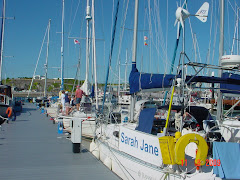
The Raymarine chartplotter on “Sarah Jane” is equally as accurate, showing our position on the pontoon at Mylor. Linked to the autohelm it follows a track far better than we can. It gives position far more accurately than any traditionalist could have dreamed of.

Without a doubt GPS has in recent years transformed and simplified all types of navigation, at sea, in the car and on foot.
When GPS is working properly it is a fantastic tool for the sailor. That is the problem – WHEN IT IS WORKING PROPERLY.

All GPS users will know the symptoms, position indicator jumping around, unable to show a position, or wildly inaccurate position. We were once shown to be miles away from our known position and at 32000ft, not on the sea ( we later found out that the USA had invaded Panama).
Twice we have lost all satellite for some time. The first time was mid channel when both the Raymarine chartplotter and below decks Furuno lost the fix at the same time. No satellites were visible on either unit. By “coincidence a Nimrod was circling overhead during the time the signal was lost. The second time was a few miles from Plymouth, both onboard GPS showed no satellites. A third hand held GPS indicated no satellites. Again, by coincidence several naval warships were entering and leaving Plymouth at the time. In our case the most common cause of GPS not working is lack of battery voltage, after a few hours sailing using the autohelm the house battery voltage would drop too low and the GPS would switch off. This partly solved by fitting a wind generator and new battery.

To reduce the difficulties arising from the loss of GPS we routinely plot our position every ½ hour or hour on a traditional chart. As well as a the security this also gives a much better overview of progress and the effects of tide and wind.
Of greater concern inshore is the the possibility of inaccuracies in the electronic chart, omissions or out of position hazards or marks. Because of this when entering or leaving an unfamiliar harbour we rely chiefly on traditional chart pilotage, leading lights or lines or buoyed channel. The final GPS waypoint is one that brings us to the point where traditional pilotage takes over, but even then there are circumstances when its useful to be able to quickly plot an accurate GPS fix on the chart to verify you are where you think.

Make certain the chart GPS datum is the one programmed into the instrument. The majority of charts use WGS84, but a few use OSGB. Be careful when using a handheld GPS that the datum has not been set to OSGB36 for walking.

The GPS will give an accurate lat/ long position and it is possible to plot this directly on the chart, but this a little laborious and prone to human errors, especially if the boat is pitching around.

A much simpler method of position plotting is to use bearing and distance TO a fixed point on the chart.

Make the centre of a compass rose on the chart in use a waypoint. Program the lat/long of the chosen compass rose into the GPS as the destination waypoint. The GPS will then give your position’s bearing and distance to the compass rose WP. And using these two values your position can be quickly and simply plotted on the chart.

To help in transferring this fix to the chart I have made the very plotter shown below. The thin plastic sheets used were off cuts bought for a few pence from a sign maker.

The distance scale is taken from the latitude scale on the chart in use.

We use Imray C series charts for most coastal cruising. Many have the same latitude scale so one plotter has been marked permanently with distance for use with these charts.


Other plotters have been made without a distance scale. Stick a strip of masking or white electrical tape along the working edge, hold against the latitude scale of the chart used and mark of the distance.


When cruising we set the destination WP of the chart table GPS to the chart compass rose and and read off the GOTO information as required.

In the example below the plotter has been made for use with chart 5604.13 (one of the Admiralty Channel Island folio).

The compass rose from the chart as been entered as WP 5604-13 into the GPS.
At the time of the plot a GOTO showed :-
Bearing to WP 047o(T) and distance to WP 3.61NM.
The position is plotted as shown below.


Last year after leaving Dartmouth for St Peterport I decided to check the GPS by taking bearings of Start Point and Berry Head. The result was wildly out, showing us just off Start Point. I checked several times, with various results, but always miles from our known position. It was only recently I realised the cause of the error. My clip on sunglasses are held in place by small magnets fitted to the glasses frame.


Thursday 29 July 2010

Home in Mylor

“Sarah Jane “ is now safely tucked up in her home berth at Mylor.

Since leaving Dartmouth we’ve sailed most of the way with the wind from the south west or west and the tide in our favour, very useful when rounding Start Point and Dodman, although we used the engine little bit between Plymouth and Fowey.

We visited the River Yealm on the way, staying overnight on the visitors pontoon just off Warren Point. We managed to get into the last available space on the river side of the pontoon between two boats, not too difficult, there was no wind and there was a steady flood tide helping us to ferry glide in. Getting off the pontoon was much more difficult the tide was flowing out very fast along the pontoon from our stern, occasionally sweeping on or off the pontoon. There was also a strong wind pushing us onto the pontoon. I was hoping the downstream boat would leave before us but they were staying all day. Having twin rudders, hence no prop wash, doesn’t help in these situations. The only safe was to spring the stern off into the current and go off backwards. Using our big ball fender as a pivot we eventually managed, using full forward power the get the stern round far enough for the tide to overcome the wind and reverse out. We’d enlisted the help of the owner of the powerboat at our stern to make sure our spring line came off ok and also to walk our bow upstream a little way as we came out. He was probably concerned about his boat and more than happy to help. We were a bit concerned that the wind may blow us against the stern of the power boat and were ready to fend off but in the end this wasn’t needed. Boats on mooring buoys were swinging across the tide quite close to the pontoon adding to the fun, guides do warn that this may make turning for large boats difficult, no mention of smaller ones. At times like this we wish we had a bow thruster, quiet or noisy.
Next time we visit we’ll either go to the upper pontoon or pick up a mooring buoy.
“Runcible Moon” our pontoon neighbours in Mylor were on a buoy a little downstream of where we moored. We ate at the Yealm Yacht Club that evening. The clubhouse was very crowded, since it was their regatta the following day, but the food was good. The only black spot, literally, was a plague of flying ants which descended on the area that evening.

We had intended the following day to go up the River Tamar as far as Cargreen. There’s a pub there, The Crooked Spaniard, that Wickersley Joggers visited a couple of years ago during a Cornish weekend. Their mooring buoys are free if a meal is eaten in the pub. However, a couple we met at the Yealm told us the pub has shut down. We tried phoning to confirm this but there was no reply, so we decided not to risk it and go on to Fowey instead.

Fowey was very crowded, we rafted up against a Belgium boat that turned out to be going on the Mylor. We ate at the Gallants Yacht Club where there is a Thai cook with a very good reputation amongst visiting yachtspeople. We ate spring rolls, calamari and Thai style Fowey Mussels. Very good, the cook’s reputation nwas definitely intact. Once a week , Friday we think,they have a Thai tasting evening.
As we were getting out of the dinghy at the town quay a drunken young lad fell off the pontoon into the river. His mate, who was also drunk, managed to grab him to stop him sinking. We tried to pull the helpless lump out of the water but couldn’t, he was too heavy and the other youth was no use at all. Fortunately the Harbour Master was nearby and between us we managed to pull him out. He stood there swaying and eventually fell again, but this time into their dinghy. In spite of strong advice from the Harbour Master to take the water taxi they insisted on going by dinghy and set off weaving across the river to Polruan, shadowed by the Harbour Master. The same HM came to collect our mooring fees the next morning. The two drunks managed eventually to find Polruan but one went for another swim ( or sink) when getting out of the dinghy,but the water was very shallow.
Next day we set off on the final leg of our holiday, from Fowey to Mylor. We had another good sail, from the mouth of the river Fowey to the Castle buoy off St Mawes then started the engine for the short distance to Mylor.

All that remains of the holiday now is to clean the boat and unload it, especially the wine. We shall be down again in a couple of weeks so will leave some stuff on board.
By the time we get home on Thursday we will have been away for six weeks and travelled 562 miles through the water. Since the tides have been with us much of the time we suspect distance over the ground will be much more.
For the next trip we shall have to see if either of our GPS measure actual distance travelled over the ground rather than planned route miles.

PS. The herbs survived well, except for one coriander, which turned to seed. They all came in useful, especially the Basil.

Wednesday 28 July 2010

Back to England

We stayed in Cherbourg for two days, just long enough to stock up our annual supply of wine from “Wine World” in the local Carrefour supermarche. They delivered it to the boat at the marina. It’s all stowed in the front cabin, the only concern is that we’ll lose speed because the prop will be out of the water. We also bought some wine barrels, not high quality stuff but easy to drink and stow.


We were glad this didn't raft up to us in Cherbourg. Imagine the crew stomping all over your boat when they went off for a quick pillage.


While at the supermarket we bought a bag of cooked large prawns for lunch, about ½ kilo for €4, which we ate with a mayonnaise and tomato dip. When we were in Jersey we had bought in the fish market several very large scallops ( some about the size of coffee cup saucers), 2 king size prawns and a huge handful of calamari, all for less than £10. We ate these for dinner with rice and a creamy lemon sauce. In England we’re surrounded by water but have great difficulty buying high quality seafood at a reasonable price, even by the coast. Why? I suspect that most of what is caught in the UK goes to France or Spain.


We said our farewells to John and Mary, and crew, in Irish Odyssey who were setting of the Chichester in the morning. They were returning the boat to the UK after keeping it in Brittany for several years.


We left Cherbourg early in the morning to catch the west going tide to Braye, Alderney. There was absolutely no wind so we were forced to motor all the way, but the tide was with us and gradually increased as the journey progressed. Two hours after leaving the pontoon we were again at Cap de la Hague with a 5 ½ knot tide pushing us along. Some care is needed here to make sure the SW stream doesn’t carry you down the coast and South of Alderney, again the vectors on the chart plotter proved useful. We were a little concerned that if the strong tide continued there would be a risk of overshooting Braye harbour , but when we reached the north coast of Alderney the tide slackened to a mere two knots and we entered the harbour without a problem.
In the past it was very difficult to pick out the leading marks and lights for entry into Braye but these have obviously been replaced and are now very visible even in bright daylight.
We use the chart plotter a lot. It’s a very useful tool and makes navigating easy, but like to use it to get us to a point where leading lines or lights can be used for pilotage.
Shortly after we arrived a sea fog descended and we couldn’t see the end of the breakwater from our mooring.
Alderney is not our favourite Channel Island although many people love it. Last year the whole island appeared shut because the daughter of the fish & chip shop owner was getting married. We got the impression everyone in Braye and St. Anne was attending.
This trip Jill had missed a meal at one of her favourite restaurants in Cherbourg because it was shut Monday and we were leaving Tuesday, so I promised to treat her at the above chippy in Braye. We took the water taxi ashore to find it only opened Wed/Thurs/Fri/Sat. By that time most of the shops had shut so it was back to the boat for a healthy meal of sausage with onion gravy and mash.
Next day we were up before dawn for the crossing to Dartmouth, and as soon as there was enough light to see a pot buoy we set off, “following” the very bright leading lights out of the harbour. The distance across was 65 miles, a 13 hour trip and we had worked out that the effect of cross tides over that distance would be less than a mile, in our favour. So after clearing the harbour we set course on a direct bearing to Dartmouth. The forecast was for SW F 3-4 but as we set off in the rain with no wind we were anticipating a miserable crossing. Soon though the rain stopped and as the Sun rose above the horizon we had a late breakfast.
The course set took us at an angle across the Casquets shipping lanes. These have to be crossed at right angles so we changed course and motor sailed at maximum speed to clear them as quickly as we could, keeping a good look out visually and on radar, visibility was very good. In the eastbound lane 7-8 ships passed us a good distance away, as predicted by radar and confirmed visually. Another ship was more of a problem, one minute the radar showed it passing a few hundred feet ahead, the next a few hundred behind and the next straight through us. When viewed through binoculars neither its bearing nor aspect was changing, so we decided to play safe and sailed a reciprocal course for about a mile. When we resumed the original course it passed ahead of us about a mile away so we were probably wise to take evasive action. In the westbound lane 9-10 ships passed us, all at a safe distance. I later estimated the diversion needed to cross the shipping lanes added about 4 miles to the straight line distance, the best part of an hour extra sailing time.
While we were crossing the shipping lanes the wind increased to the forecast force 3 and as soon as we left the lanes we started to sail and stopped the engine. For the next 8 hours we sailed on the same tack, either close hauled or on a close reach, on the same heading all the way to the entrance of the River Dart. This was the longest and best sail of the whole trip.
We had one diversion when the clip on backrest bought in Guernsey popped off into the water. We did a quick about turn and in spite of the choppy seas managed to find it again, but couldn’t fish it out again because there was nothing to hook on to.
About 20 miles from Dartmouth the wind increased to force 4 and above and the autohelm began struggling to keep a course so we reverted to hand steering. Eventually we put a single reef in the sails, from the safety of the cockpit without losing much time. Having reefed the boat sailed much better without any reduction in speed and the autohelm was able to cope again, making the rest of the remainder of the journey easier; it holds a much better course than we can.
This sail was the longest without engine since leaving Falmouth. In previous years when sailing the voltage on the fully charged battery would drop the after about 4 hours, the first indication being the autohelm starting to sail in circles, then even with the Raymarine chartplotter turned off the voltage would drop below 11 volts and the Furuno GPS would switch off, forcing us either to sail without some instruments or run the engine to put some charge in the battery. I fitted a Rutland wind generator last year which helped but didn’t cure the problem. I suspected the battery even though it was checked out and declared healthy. This year I fitted a slightly larger capacity, deep cycle battery. This year with the wind charger and new battery the voltage was still around 12.5 after 8 hours sailing with autohelm, chartplotter and occasional use of the radar.
Much to our surprise when we entered Dartmouth, 13 hours after we left Braye, there was a vacant berth on the inside of the town quay. We were helped to raft up to another boat by two sailors from a beautiful Oyster 82 yacht called “Zig Zag” moored on the outside of the quay.
We were able to walk into town and get the fish and chips we had missed in Braye, just in time they were the last two left and the shop was about to shut.
One more consolation; “Zig Zag” had to leave early the next morning to leave the outer side of the

Tuesday 27 July 2010

The Race to Cherbourg

This part is a bit for sailing folk thinking of going from Guernsey to Cherbourg.
Our passage from Guernsey to Cherbourg would take us through the famous or “infamous” Alderney Race. This notorious stretch of water runs between the island of Alderney and the French coast at Cap de la Hague. Every six hours the tide floods through this narrow stretch of water, the six hours later runs back. Tidal streams can run at up to 9-10 knots with heavy over falls and breaking seas. Since the average small sailing yacht travels at 5-6 knots under the wrong conditions or at the wrong time the race can be difficult or dangerous.
We had decided to leave for Cherbourg on Sunday when the forecast showed the strong winds should have dropped to F3-4 from the W or SW.
Reeds almanac suggests leaving St. Peter Port about 3 hours after HW Dover. This gives an adverse tide for the first 2-3 hours after which it changes to favourable. Leaving St. Peter Port at 0730 when high water Dover was 0431 and keeping up a speed of around 5 knots would mean the tide changing in our favour when we were just a couple of miles SW of Alderney, the tide being with us in “the Race” but by no means at full flow. We would then have a positive tide all the way to Cherbourg; that was the plan. Our enforced stay at least meant we would be leaving at a reasonable time, not the crack of dawn.
We had been to Alderney twice before. The first time we had taken the southern route, following the timings in the pilot books, inside Inner Race Rock, round Blanchard Rock to the East of Alderney then North to pick up the west going back eddy into Braye harbour. This passage went well with no over falls. Last year we decided to take the route north of Alderney through “the Swinge”. This was more interesting. It was close to neaps when tidal steams would be expected to be at their weakest, we arrived not long after the tide had turned to run NE and we had a gentle SW wind pushing us with the current, all ideal conditions?? The actual tide running was much faster than predicted in the atlases reaching 7-8 knots at one point. The chart showed heavy overfalls in the middle of the “Swinge”; we passed this point with little disturbance and were relaxing when we hit the overfalls to the east of the Swinge. They were short and very steep. The wind was light, so we were only doing about 3 knots through the water, about 9-10 SOG. We started the engine to give more control and to speed us through, and passed through them without major concerns.
Andy, who lives in Guernsey, leaves St Peter Port as soon as the marina opens on the rising tide then picks up a N/NE going stream immediately, up the Little Russell, North of Alderney through “ the Swinge” and straight to Cherbourg on one tide.
We decided against this option because we went through “the swinge” last year and we also wanted to fill up with diesel, at £0.48 per litre, in Guernsey before we left. By the time we had left the marina and filled up with fuel another hour could have passed and the race could have been in full flow and the tide may have changed before we reached Cherbourg. So we left the marina at high water Saturday, filled up and moored up on one of the outer, all tide, pontoons just ahead of “Irish Odyssey”.
John and Mary of “Irish Odyssey” were also leaving for Cherbourg at 0730 Sunday so we arranged to keep in radio contact during the journey.
As planned we left at 0730, hoisted both sails (unfurled one) just outside the harbour and set off up the” Little Russel”.
There were two cruise ships anchored just off St Peter Port, the Balmoral and a massive ship the Princess something. Their tenders were already running some people ashore. Why? I can’t imagine there’s too much to do in St. Peter Port at 0730 Sunday morning; perhaps they were all going to church.
Going up the” Little Russel” the tide, as expected, was running against us at up to 2 knots, but with the engine running and a fresh breeze from the South behind us we were able to make a reasonable speed over the ground. Unexpectedly at the top of the Little Russel we picked up a back eddy going our way which pushed us along witht a good two knots.
After clearing “Platte Boue” we set a course for a waypoint 1nm south of “Race Rock”. With a combination of NE course, tide from the NW and a Southerly breeze we gained another unexpected push from the tide of about 1 knot, it all helps and we were able to turn off the engine and keep up a speed over ground of about 5 knots. Unfortunately the cross current was pushing us towards the French coast where the overfalls are the heaviest. We were hoping the tide would change before the cross track error became too large, but just SW of Alderney we ran upwind for a short while to reduce the error. At the same time it became obvious that the tide was beginning to change and we were able to resume our heading and make the “Race Rock” waypoint. The tide gradually increased and by the time we reached “Race Rock” was giving us an extra 6 knots.
We were surprised just how smooth the passage had been up to and past “Race Rock”. This secure, warm feeling was short lived as we hit the overfalls about a mile NE of the rock and for the next half an hour had a very bumpy ride.


Our next waypoint was just to the NW of Cap de la Hague , but the strong N /NE tidal stream was pushing us off track and to stay on course to the waypoint the nose was pointing SE toward Nez de Joburg . At the same time the wind began to drop as it backed from S to SE. With the boom flopping around we restarted the engine.


One really useful feature of the Raymarine system we have is the display on the chart plotter of boat heading vector and course over ground vector, especially in strong tidal situations such as the above.
With hindsight it was a mistake to try to correct for the current and stay on track. We should just have let the tide push us northwards beyond Cap de la Hague, there were no dangers, until we met the east going stream from the north of Alderney. This would have cleared the overfalls much more quickly.
As we said at the time “there’s no point going through the Alderney Race and having to tell people it was flat”.
We were disappointed once we had rounded Cap de la Hague by the relatively weak east going stream towards Cherbourg, 1-2 knots. When we had sailed from Braye to Cherbourg last year the tide further away from the coast had kept up 5-6 knots for some distance and it was obvious that boats further out were gaining a tidal advantage. Had we let the tide in the race push us north we would probably have joined this stronger stream.
Still we couldn’t complain too much. Since Leaving the Little Russel we had sailed all the way, apart from about ½ hour around Cap de la Hague and had picked up a good push from the tide all the way. The tide was still with us as we entered Cherbourg’s outer harbour past one of the very impressive breakwater forts, seven hours after leaving the pontoon at St Peter Port. The distance on the chart from pontoon to pontoon is 44 miles, we clocked 30 miles through the water.
Having experienced both routes next time we make the trip we’ll probably take Andy’s advice and go through the “Swinge” . The overfalls are much shorter in distance and it should then be a straight run with a good tide all the way to Cherbourg.

Monday 19 July 2010

Back to Guernsey

Because of the “Manche Tour “ race we decided to avoid the French coast for a few days and stay in the Channel Isles. There was the prospect of a storm coming through later in the week so we decided to move on the Guernsey after just a couple of nights in St Helier. We much prefer Guernsey to Jersey, so if we were to have an enforced, extended stay in port we would prefer to be in St Peter Port marina. The only possible problem was on the day we were to sail “the race” would be heading from Carteret to St Peter Port, but, if we set off early, as planned we would arrive well ahead of them, assuming they had a midday start time.
With the wind from the South force 3-4 to start, so we had a good sail, almost running, with a strong helping tide until about 5 miles from St Peter Port when the tide turned to across us and the wind dropped to nearly nothing. So, since we were in no hurry, we “drifted” towards St Peter Port, having lunch on the way and taking a further 3 hours to arrive. Just after leaving Jersey we had been overtaken by several sailing boats hurrying under engine. When finally arrived in Guernsey several were the waiting on an outer pontoon for the marina to open in another three hours. Because of the queuing system we entered before several of them.


We arrived in Guernsey on Tuesday intending to stay for a couple of days, but high winds later in the week delayed our departure so we ended up having a very pleasant five days in St Peter Port. We met up again with Carolyn and Andy and had dinner in two restaurants, main in one and cheese and puddings in another, the “Petit Bistro”. We had tried to book into the latter for the whole meal, but it was Bastille Day, so was full of celebrating French people. Next time we visit Guernsey it’s a must. The 2CV in nthe background is a real one cut in half.


We rafted up against another Falmouth boat, a Westerly called “Golden Eye” owed by George and Rachel Curnow on their back to Cornwall. They were MYC members but now belong to the RCYC.
On Guernsey we always do a fair amount of walking and some cycling, most motorists are very pedestrian and cyclist friendly. We also like the local bus service which seems to serve every little hamlet on the island. Hop on a bus in St Peter Port, get off where you want to start walking and when you’re tired it’s never more than a few hundred yards from a stop, and if the bus comes when you’re between stops stick out a hand and the chances are it stops ( just like England!!).

On Friday Castle Cornet was open for an evening of music and short plays. We were sitting on the boat contemplating whether to go or stay where we were after a longish walk. Fortunately Andy and Carolyn came along and made our minds up for us otherwise we’d have missed a very enjoyable evening. Better still it was free. One of the bands performing was a drum band “Samba Burros” who play a variety of very infectious music. We first came across this type of band at the Cherbourg music festival last year.
Skat the large private yacht we saw in St Malo was in St Peter Port, according to one of the crew they are going to Falmouth. They’re stalking us.
We're off to Cherbourg next.

Sunday 11 July 2010

Eastward to St. Malo and beyond

After a quiet night in St Quay we set of to work our way eastward.
Before leaving we went early morning to the poissonarie and bought a very fresh Ray wing to cook when we arrived.
Again no wind at all when we set off. After leaving St Quay we headed North for a mile or so to clear a rock island running parallel to the coast then headed due East across St Brieuc Bay ( Baie de Saint Brieuc) to cap Frehel. This was slightly longer than the more southern route we had taken westward to St Quay but was a simpler.
In the bay there were large numbers of small fishing boats and a several stern trawlers. The latter are a bit of a nuisance when fishing since they change direction very erratically. Then when the nets are up they set off at high speed to the next fishery. If you’re in the way they head straight towards you and the concern is whether they’ve seen you. Sometimes the skipper can be seen on deck working with the crew sorting the catch, before rushing top the wheelhouse to change course. They also trawl up masses of seaweed which floats to the surface ready to get caught round the rudder or prop. Still, without them you probably wouldn’t be able to buy fresh ray wing early morning.
Just after lunch, off Cap Frehel, the wind sprang up enough for us to sail the rest of the way to Bas Sablons marina just outside St. Malo. We would have no problems entering since it was neaps with a minimum of 2 metres over the cill at any time of the day. Just a couple of short tacks kept us inside the “Chenal de la Grande Porte” then off the wind for an easy run down the “Chenal de la Petite Porte” to St. Malo. We entered “Petit Port” just ahead of a Southerly 38, also sailing. I thought they would overtake us but we gradually pulled away and entered Bas Sablons well ahead. I’m glad we beat him, he docked a couple of boats from us and turned out to be very loud and pompous with an equally loud bow thruster that he appeared to use all the time instead of the rudder.
We ate the ray that night baked in the oven with a gram flour and almond crust, using cooking bags. The fish cooked OK but was difficult to get out of the bag so the crust got a little damaged but tasted OK. We needed fresh cream for the caper sauce, but found it impossible to find in the small local supermarket, so had to use crème fraiche instead, if anything this made the sauce better. The fish was very good, just what you’d expect straight from the quay. Next time we’ll try and stop one of the trawlers as the flash past a few yards away and buy some.
Our plan is to stay three nights in St Malo.
We went to one of our favourite restaurants, in St Servan. Food as good as ever and prices seem lower than last year, someone told us that the tax charged in restaurants has gone down and most have passed this on to customers. Generally though, food and clothes in shops are very expensive.
Since being here we have done a lot of walking, around St Servan and St Malo. We also took the ferry across the river to Dinard. It’s only a small town but it has several miles of very pleasant water front to walk along.
In the basin Vauban in St Malo is moored a very large superyacht named “Skat”, privately owned and registered in the Cayman Islands. According to one of the crew they have no permanent home port but just travel the world and the owner joins them. A very sleek new 60/70 ft powerboat from Guernsey came into Bas Sablons, turned round and went out again, It was called “Envy”. Next day it was moored right behind “Skat” looking very small and insignificant. No matter what boat you have there’s always one bigger.


From the sea wall at Bas Sablons there is a marvellous view of the Sun setting in the west. We have been to view two nights. The fist night there was a bank of cloud on the horizon but the second night was very clear.

Next stop is Granville just up the coast. Should be “Open All Hours”, but it’s tidal with entry 3 hours either side of high water. We will leave in the morning on the falling tide, as late as we can leave it but still clear the cill, and arrive at Granvlille late afternoon on the next rising tide. By which time there should be plenty of water over the cill there. It’s only 22miles so we should make it comfortably, even allowing for some adverse tidal streams.
Arrived at Granville around 4.00 pm, the entrance had opened at just after 4.00 ( ht of tide at St Malo 6.0m). The visitors pontoons are, surprisingly, fairly empty. We tied up next to “Irish Odyssey” who we’d been next to in Bas Sablons, but had left on Friday. Found out why the place is relatively empty. The “Tour de Ports de Manche” race takes place over the next week or so. The route is: Jersey, Granville, Carteret, Guernsey, Cherbourg and finishes in St Vaast. All the visitors pontoons have been pre-booked by the race organisers until Monday so ALL visitors have to leave in the morning; definitely NOT open all hours. Granville is also expensive at €36 compared to the typical €24 we have been paying. To top it all the electricity went off last night and is still off this morning.

This race has fouled things up because they are due to visit the French ports we want to go to so we will have the same problem elsewhere. We have decided to go back to Jersey, then head to Cherbourg ahead of them.
We left Granville early Sunday morning under a grey sky with a stiff westerly breeze, needing a reef in the sail. Within half an hour the wind had dropped and the reef was taken out. After this we had the first decent sail since leaving Falmouth, with the wind a fairly steady force 3 for most of the trip. The wind dropped to a very gentle breeze about 5 miles from St. Helier, but we were in no hurry to arrive since the marina could not open until late afternoon and were determined to sail all the way, helped by a 2 knot tide all the way
About 3 miles from St Helier we met the “Tour de Ports” fleet just after their start. A single boat, us, on a port tack sailing through 130 racing boats all on starboard was going to be interesting. Fortunately, we were close hauled and they all had spinnakers set and passed down our starboard side apart from a few stragglers at the rear.

We are now in St. Helier marina in almost the same spot we left a couple of weeks ago.

Tuesday 6 July 2010

On to Tréguier

Sunday 4th. July Independence day
As expected the day started sunny and hot, with just enough wind to make manoeuvring in the marina interesting. Picked up fuel then set off, around 10.00am to Tréguier, a trip of about 33miles. Motored on a flat sea for the first 3 hours, then the wind started to increase and we ended up having our first real sail since leaving Falmouth. We even ended up putting one reef in the sails. Not because of safety, but because when the wind reaches about 13/14knots and we are close hauled, reducing sail reduces heel and weather helm ( less rudder drag) and the boat is much quicker.
We had been warned by several people, also in sailing guides, of very strong tidal streams that can run through the marina pontoons at Tréguier, making mooring up tricky. We had expected to arrive at around 3.00pm and to have to stay on the waiting pontoon for the tidal stream to slacken before entering the marina, but, because we sailed we travelled further than expected and arrived just at low water, so went straight into a berth.


Tréguier lies about 6 miles upriver from the sea, the channel is well marked and we managed to sail, apart from the last mile. It is very similar to rivers in Cornwall or Devon even down to the riverside houses and boathouses scattered along the banks and part hidden in the trees. It’s just like being back in the River Fal.
Went for a walk around Tréguier, some distance from the marina and an uphill climb to the medieval town centre It has an interesting Cathedral, with what looks like a modern spire, and houses some bones of St Tugdual and the scull of St Ives. A pleasant, sleepy small city with few shops and a number of restaurants.


Mustard M**t ( see Jersey Jaunt) arrived in Tréguier. Jill unknowingly tried to have a conversation with the woman onboard, but was “blanked”. I pointedly passed the time of day with the skipper and received a slight nod for my trouble.
Very windy today and with the swift tide it has made it a challenge for incoming boats. A good spectator sport but most people lend a hand, apart from certain burgee owners in classic yachts. Three “Glenans” sailing school boats came in with mostly teenagers on board. I thing the “Calais moor” must be an accepted technique, taught in French sailing schools.
There was one bar in the town centre, housed in an old building, a dark entrance and interior with what looked like flashing neon lights at the back. Every so often a drunk would stagger out weave his way home swaying. We passed it again on our way back to “Sarah Jane” after a moules et frites supper at a very nice Moulerie, in the Place Coatcolzezou?? near the Cathedral, well worth a visit for the atmosphere. Jill grabbed me and pulled me past the bar, so I still don,t know the attraction.


All this walking, to Binic, up and down the hill to Treguier has made me lose weight. In fact Jill says I am looking too thin in the face, gaunt.


Our plan is to return to St Quay for a stopover night then go on to St Malo. We left early next morning just before low water to get the last of the ebb tide down river.
An inshore shortcut “Passe de la Gainne” saved us 3-4 miles on the return. This takes a channel between rocks at one point less than 50metres, wide but seems more like 20. We hadn’t even considered this passage on the way in because of the moderate seas and sailing would have made it difficult to follow the leading marks. No problems on the return because again we were motoring with no wind and flat seas. Having done it I still wouldn’t consider it in high winds.
Altogether the return trip was about 11 miles shorter than out; we motored in straight lines between marks, no tacking. This, with a favourable tide, meant we were back in St. Quay by lunchtime.


On the way across we saw this “flock” of several hundred Cormorant, or similar, on the sea, obviously over a shoal of fish.

"Don't panic everybody" the seagull is saying.